
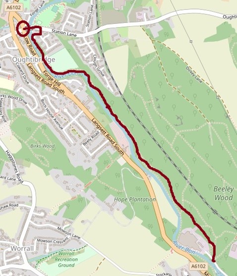
Description
A linear woodland route along the bank of the River Don, with beautiful views of the river and its wildlife. The route follows the eastern bank of the river and is completely off-road.
The path is 2 m wide and is generally flat with some slightly narrower sections and short gentle gradients.
Information
- Length – 2.5 miles (4 km) in total (outwards and return)
- Time – approximately 30 minutes one way
- Start – Oughtibridge village centre
- Grid Reference SK 308 934
- Parking – on-road parking, Oughtibridge
- Public transport – bus routes SL1 and 57 stop in Oughtibridge village centre on Langsett Road North. Bus 57 starts from Sheffield Centre Interchange, bus SL1 starts from Middlewood Supertram stop/Park and Ride. From the bus stop, continue in the same direction, then turn sharp right at Lulu Mae bridal, (the ex-White Hart pub) onto Low Road. At the bottom of this gentle hill cross over the bridge to your left onto Station Lane. The return bus stop is on Low Road, kerb-free from the end of the route.
- Accessible Refreshments – The Cosy Café in Oughtibridge (7-9 Langsett Road South, S35 0GY) is wheelchair accessible. There are parking spaces along the road next to the café and the kerb is approximately 2 cm high, low enough for a powered wheelchair to manage. The road directly from Oughtibridge to the Cosy Café on Langsett Road South is steep. However, Low Road and Langsett Road North offer a slightly longer but gentler alternative route to the café.
- Accessible Toilets – RADAR key operated public toilets in Coronation Park, Oughtibridge. The Cosy Café has an accessible toilet.
- Seating – there are no benches but occasionally there is a tree stump or fallen log at the side of the path.
Access Information
Road/off road: The route is completely off road, apart from crossing roads in Oughtibridge village. There are dropped kerbs at all the crossing points (1). The woods continue beyond the end point described here, but the only further access is along a quite busy single lane road with muddy verges and no pavement.
Width of path: The path is mostly 2 m wide, but there are some places where it is narrows to approximately 1.5 m.
Surface: The path is concrete. Occasional shallow muddy patches. There is tactile paving at a crossing point by the turn-off to Waterside Gardens.
Camber: There is an occasional slight camber, but the path isgenerally flat.
Gradients: The path along the river is mostly flat but there areoccasional short gentle gradients approximately 1:15 steep and approximately 7 m long. The road directly from Oughtibridge to the Cosy Café on Langsett Road South is steep. However, Low Road and Langsett Road North offer a slightly longer but gentler alternative route to the café.
Rails/edges: At the start of the route there are metal railings forapproximately 100 m on the left-hand side of the path. There is foliage, trees, rocks, and mud/earth on each side of the path.
In several places there is a fairly steep drop away from the path on the river side. The distance between the path and the river is variable but there are no sudden drops between path and water. At the end of the route there is a stone wall for approximately 50 m close to the right-hand side of the path.
There are no painted lines at the edge of the path.
Obstacles: In one place toward the end of the route there are trees in the way of the path. The path goes around the trees. There are no stiles, gates, or narrow plank bridges. At the time of writing there were no obvious overhanging branches.
At each end of the route there is a gap wide enough for wheelchairs to go through. It is 95 cm wide, which narrows at a height of 87 cm to 57 cm wide.
Download the route information and gpx data.
Map of the route
Mobile Phone Coverage – Mobile phone signal coverage is mostly good in this area. Intermittent signals can be received on higher ground.
Ordnance Survey map OL1 Dark Peak is recommended for all the routes on this web site.
Great care has been taken to ensure that the information on this web site and associated documents is accurate. However, we accept no liability for any claim, loss, damage or injury (howsoever arising) incurred by those using the information provided. Except where expressly stated to the contrary, copyright in the text, graphics and information contained in this web site (including downloads) is owned by Bradfield Walkers are Welcome. You may print, or download to a personal computer, extracts for personal use. Permanent copying and/or storage of whole or part of this web site or the information contained therein or reproduction or incorporation of any part of it in any other work or publication whether paper or electronic media or any other form is expressly prohibited unless agreed otherwise.
Copyright – Stocksbridge Walkers are Welcome 2020