This route is distributed in association with Sheffield Lakeland Landscape Partnership
Description
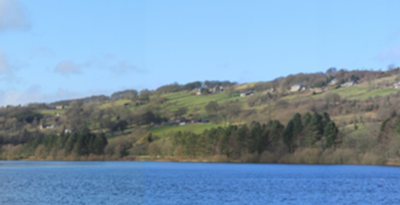
The Ewden Valley is a popular spot for a gentle stroll: a beautiful quiet location (‘The Switzerland of South Yorkshire’). This is an inclusive woodland route, accessible to wheelchair users and buggies, with great views across More Hall Reservoir towards the surrounding hills. The dam wall and south side are completely off-road; the path is generally flat and 1.5 metres wide, with some short gentle gradients and narrower sections. The route on the north side is along a quiet tree-lined road between fields and the reservoir.
Information
- Length – 2 miles (3.2 km)
- Time – 40 minutes (at 20 minutes per mile)
- Start – More Hall Reservoir Lodge
- Grid Reference – SK 287 958
- Parking – Parking spaces next to the Reservoir Lodge. From the A6102 turn off at More Hall Lane and take the small private road which forks off to the left. The area around the lodge is wide and flat and there are no kerbs.
- Public transport – bus 57 from Sheffield city centre, bus SL1/SL1A from Middlewood Park and Ride/Supertram stop. Both routes stop by request at the junction of More Hall Lane and the A6102. This is half a mile from the Reservoir Lodge, up a gentle but consistent gradient of approximately 1:15. There is no pavement and the edge of the road is soft and muddy.
- Accessible Refreshments –
- Cosy Café, 7-9 Langsett Road South, Oughtibridge, Sheffield S35 0GY, phone 0114 286 2261. There are parking spaces along the road next to the café and the kerb is approximately 2 cm high, low enough for a powered wheelchair to manage.
- numerous refreshment options at Fox Valley Retail Park.
- Accessible public toilets –
- RADAR key operated public toilets in Coronation Park, Oughtibridge.
- The Cosy Café, Oughtibridge has an accessible toilet.
- Brearley House, Fox Valley Retail Park. This is near the front entrance to the retail park. Take the lift to the first floor and follow the hallway round to the right.
- Seating – There are benches approximately every 200 m.
Download the route information and gpx data.
Map of the route
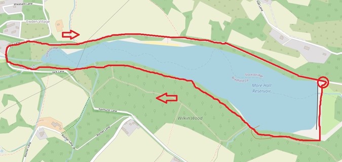
© OpenStreetMap contributors
Mobile Phone Coverage – Mobile phone signal coverage is mostly good in this area. Intermittent signals can be received on higher ground.
Ordnance Survey map OL1 Dark Peak is recommended for all the routes on this web site.
Great care has been taken to ensure that the information on this web site and associated documents is accurate. However, we accept no liability for any claim, loss, damage or injury (howsoever arising) incurred by those using the information provided. Except where expressly stated to the contrary, copyright in the text, graphics and information contained in this web site (including downloads) is owned by Bradfield Walkers are Welcome. You may print, or download to a personal computer, extracts for personal use. Permanent copying and/or storage of whole or part of this web site or the information contained therein or reproduction or incorporation of any part of it in any other work or publication whether paper or electronic media or any other form is expressly prohibited unless agreed otherwise.
Copyright – Stocksbridge Walkers are Welcome 2020